Land is one of the most valuable natural resources on Earth. It supports agriculture, housing, industries, forests, transport systems, and ecological balance. However, land is used in many different ways, and understanding those uses is important for planning, conservation, and sustainable development. This is where land use classification becomes important.
For beginners, land use classification may sound technical, but the concept is straightforward. It simply refers to grouping land into categories based on how people use it or how it functions. From farmland and forests to urban settlements and industrial zones, classification helps organize land according to purpose and management.
Moreover, land use classification is widely used in geography, environmental science, urban planning, agriculture, and engineering. Therefore, understanding its basics is valuable for students and professionals alike.
What Is Land Use Classification?
Land use classification is the process of categorizing land into different groups based on how it is used by humans or managed.
It helps identify and organize areas such as:
- Agricultural land
- Residential land
- Commercial land
- Industrial land
- Forest land
- Recreational land
- Transportation corridors
- Conservation areas
Because land serves many purposes, classification creates a systematic way to understand these uses.
Why Land Use Classification Matters
Land use classification is important because land resources are limited.
Proper classification may help support:
- Better land planning
- Resource management
- Sustainable development
- Environmental protection
- Infrastructure planning
- Agricultural management
As a result, it plays a major role in decision-making.
Difference Between Land Use and Land Cover
Beginners often confuse land use and land cover.
Although related, they are different.
Land Use
Land use refers to how people utilize land.
Examples include:
- Farming
- Housing
- Industry
- Recreation
It focuses on human purpose.
Land Cover
Land cover refers to the physical material covering the land surface.
Examples include:
- Forests
- Grasslands
- Water bodies
- Bare soil
It focuses on what physically exists on the surface.
Therefore, land use and land cover are related but not identical.
What Is Land Use Classification Used For?
Land use classification has many applications.
It may support:
Urban Planning
Cities need organized land allocation.
Classification may help plan:
- Residential zones
- Commercial districts
- Road networks
- Public spaces
As a result, urban growth may become more organized.
Agriculture Planning
Agricultural land classification may help manage:
- Crop areas
- Irrigation planning
- Soil use decisions
This can support productivity.
Environmental Management
Classification may support:
- Forest conservation
- Watershed management
- Protected area planning
- Ecosystem monitoring
Therefore, it can aid sustainability.
Infrastructure Development
Roads, railways, and utilities often rely on land use planning.
Classification may help identify suitable zones.
Disaster Risk Management
Land use mapping may support planning in hazard-prone areas.
This may be relevant for:
- Flood zones
- Landslide-prone areas
- Coastal vulnerability planning
Major Types of Land Use Classification
Land can be classified into several major categories.
Although systems may vary, common classes include the following.
Agricultural Land
Agricultural land is used for farming and related activities.
It may include:
- Crop cultivation
- Orchards
- Plantations
- Pasture land
Because food production depends on land, this category is significant.
Residential Land
Residential land includes areas used for housing.
Examples include:
- Urban housing areas
- Rural settlements
- Residential neighborhoods
This category supports human settlement.
Commercial Land
Commercial land supports business activities.
Examples include:
- Markets
- Office districts
- Shopping zones
These areas often support economic activity.
Industrial Land
Industrial land is used for manufacturing and production.
Examples may include:
- Factories
- Warehouses
- Industrial parks
Because industrial activities have spatial requirements, classification is important.
Forest Land
Forest land includes areas dominated by trees and woodland ecosystems.
It may support:
- Biodiversity
- Timber resources
- Watershed protection
- Carbon storage
Therefore, forests are often an important land use category.
Recreational Land
Some land is used for recreation.
Examples include:
- Parks
- Sports grounds
- Tourism zones
- Open spaces
These areas support wellbeing and community use.
Transportation Land
Transport systems occupy significant land.
Examples include:
- Roads
- Railways
- Airports
- Ports
Classification helps account for these uses.
Conservation and Protected Areas
Some land is classified for environmental protection.
Examples include:
- Wildlife reserves
- Protected forests
- Wetland conservation areas
This supports ecological sustainability.
How Land Use Classification Systems Work
Land classification often uses hierarchical categories.
For example:
Broad Categories
- Agriculture
- Urban
- Forest
- Water
Subcategories
Agriculture may be divided into:
- Cropland
- Pasture
- Orchards
Urban land may include:
- Residential
- Commercial
- Industrial
This layered approach improves detail.
Common Land Use Classification Systems
Different systems may be used depending on purpose.
Functional Classification
Groups land by use function.
Examples:
- Residential
- Agricultural
- Industrial
Economic Classification
Focuses on economic purpose of land.
Examples:
- Productive land
- Commercial land
- Resource extraction areas
Planning-Based Classification
Used in zoning and urban planning.
Examples:
- Mixed-use zones
- Institutional zones
- Development zones
Different systems serve different needs.
Land Use Classification in Geography
In geography, land use classification helps analyze how humans interact with landscapes.
It may support understanding of:
- Settlement patterns
- Agricultural regions
- Resource use
- Environmental pressures
Therefore, it is a key geographic concept.
Land Use Classification in Environmental Studies
Environmental studies often use land classification to monitor change.
This may include studying:
- Deforestation
- Urban expansion
- Habitat fragmentation
- Land degradation
Because landscapes change over time, classification helps track those changes.
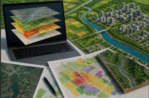
Land Use Mapping and Classification
Classification is often linked with mapping.
Land use maps visually represent different categories across an area.
They may help identify:
- Where land uses occur
- How land is distributed
- Patterns of land use change
Mapping makes classification easier to interpret.
Role of Remote Sensing in Land Use Classification
Modern classification often uses remote sensing.
This may involve:
- Satellite imagery
- Aerial photography
- Geographic data analysis
These tools may help classify large areas more efficiently.
Therefore, technology has transformed land use studies.
GIS and Land Use Classification
Geographic Information Systems, often called GIS, are widely used in land use analysis.
GIS may help:
- Store spatial data
- Analyze land patterns
- Create land use maps
- Monitor changes over time
Because of this, GIS is central to modern land classification.
Factors Influencing Land Use Patterns
Land use does not develop randomly.
Many factors influence it.
Physical Factors
Examples include:
- Climate
- Soil
- Topography
- Water availability
These may affect suitability for certain uses.
Human Factors
Examples include:
- Population growth
- Economic activities
- Policies
- Technology
These strongly shape land use.
Social and Cultural Factors
Traditions and social practices may also influence land use patterns.
Land Use Change Over Time
Land use often changes.
Examples include:
- Farms becoming urban areas
- Forests converted to agriculture
- Rural land becoming industrial zones
Because landscapes evolve, classification often requires updates.
Why Beginners Should Learn Land Use Classification
Understanding land use classification can help beginners grasp broader topics such as:
- Sustainable development
- Urban growth
- Environmental management
- Resource planning
It forms a foundation for many fields.
Common Beginner Misconceptions
Myth Land Use Classification Is Only for Geographers
It is also used in engineering, agriculture, planning, and environmental science.
Myth Land Classification Is Only About Maps
It involves planning and resource understanding too.
Myth Categories Never Change
Land uses often change over time.
Clarifying these ideas helps beginners.
Challenges in Land Use Classification
Although useful, classification can sometimes be challenging.
Reasons may include:
- Mixed land uses
- Rapid urban change
- Data limitations
- Changing landscapes
Therefore, classification may require regular review.
Why Land Use Classification Supports Sustainability
Sustainable development often depends on understanding land use.
Classification may support:
- Balanced development
- Resource conservation
- Better planning decisions
Because land is limited, efficient use matters.
Understanding Detailed Land Use Categories
In the first part, we explored the basics of land use classification. However, land categories can be studied in more detail. Because land serves many purposes, classification often uses broader categories and subcategories.
Understanding these categories helps beginners see how land is organized.
Agricultural Land Classification
Agricultural land is often divided into smaller categories.
These may include:
Cropland
Cropland is used for growing crops such as:
- Grains
- Vegetables
- Pulses
- Cash crops
Because food production depends on cropland, it is a major land use category.
Pasture Land
Pasture land supports grazing animals.
It may be used for:
- Cattle grazing
- Sheep farming
- Livestock support
Therefore, it differs from crop-based agricultural land.
Plantation Land
Some agricultural land supports plantation crops.
Examples may include:
- Tea plantations
- Coffee plantations
- Rubber plantations
These often form separate classifications.
Urban Land Use Categories
Urban areas often have multiple land use types.
Because cities are complex, classification may be detailed.
Residential Zones
Residential land may include:
- Low-density housing
- High-density housing
- Mixed residential areas
This helps urban planners organize settlements.
Commercial Zones
Commercial land may include:
- Retail areas
- Business districts
- Market centers
These areas support economic activity.
Institutional Land
Some urban classification systems include institutional land.
Examples may include:
- Schools
- Hospitals
- Government buildings
Because these have distinct functions, they may be classified separately.
Industrial Land Categories
Industrial land may also have subcategories.
These may include:
- Light industry
- Heavy industry
- Warehousing zones
- Industrial estates
Classification helps organize industrial development.
Transportation and Utility Land
Some land supports transport and infrastructure systems.
Examples include:
- Highways
- Rail corridors
- Airports
- Utility zones
Therefore, transport land is often classified separately.
Forest Land Classification
Forest land may also be grouped into categories.
Examples may include:
- Dense forest
- Open forest
- Protected forest
- Production forest
Because forests serve different functions, classification may vary.
Recreational and Open Space Land
Open spaces are often part of land use classification.
Examples may include:
- Parks
- Sports facilities
- Public open spaces
- Tourism areas
These support community wellbeing.
Water-Related Land Categories
Some systems include water bodies in broader land use mapping.
Examples may include:
- Rivers
- Lakes
- Wetlands
- Reservoirs
Because water affects land planning, these areas may be mapped too.
Land Use Classification Methods
There are different methods used to classify land.
Manual Classification
Traditionally, land classification often relied on surveys and field observations.
This may involve:
- Site visits
- Mapping records
- Visual interpretation
Although time-consuming, it can provide detail.
Remote Sensing Classification
Today, remote sensing is widely used.
This may involve:
- Satellite imagery
- Aerial photographs
- Digital image interpretation
Because large areas can be analyzed, this method is efficient.
GIS-Based Classification
GIS has transformed land use analysis.
It may support:
- Spatial mapping
- Data analysis
- Classification modeling
- Change detection
Therefore, GIS is central in modern land studies.
Land Use Surveys
Land use surveys help gather classification data.
Surveys may collect information on:
- Existing land uses
- Land ownership patterns
- Resource use
This data supports planning.
Importance of Land Use Mapping
Classification often works together with mapping.
Land use maps help show:
- Spatial patterns
- Distribution of land uses
- Development trends
As a result, maps help make classification practical.
How Land Use Maps Are Read
Land use maps often use symbols or colors for categories.
For example:
- Green may represent forests
- Yellow may represent agriculture
- Red may represent built-up areas
Although systems differ, maps make patterns easier to understand.
Land Use Classification in Urban Planning
Urban planning relies heavily on classification.
It may support:
- Zoning decisions
- Infrastructure planning
- Growth management
- Environmental planning
Because cities expand rapidly, classification becomes important.
Zoning and Land Use Classification
Zoning is closely linked to land classification.
It may regulate land for uses such as:
- Residential
- Commercial
- Industrial
- Mixed-use development
Therefore, zoning often depends on classification systems.
Land Use Classification in Agriculture Planning
Agriculture planning may use classification to support:
- Crop suitability analysis
- Irrigation planning
- Soil management
- Land capability assessment
Because agriculture depends on land characteristics, classification is valuable.
Land Capability vs Land Use Classification
Beginners sometimes confuse these terms.
They differ.
Land Use Classification
Focuses on how land is currently used.
Land Capability Classification
Focuses on what land is suitable for.
For example:
- Farming suitability
- Grazing suitability
- Conservation suitability
This distinction is important.
Factors Affecting Land Use Classification
Many factors shape how land is classified.
Natural Factors
Examples include:
- Soil quality
- Climate
- Relief
- Water availability
These affect land suitability.
Economic Factors
Economic activity may influence classification.
Examples include:
- Industry growth
- Market access
- Agricultural demand
These may shape land patterns.
Population Growth
Growing populations often increase demand for:
- Housing
- Infrastructure
- Food production
Therefore, population growth can affect classification.
Government Policies
Policies may influence land use through:
- Zoning regulations
- Conservation laws
- Development plans
Because policy shapes land decisions, it matters greatly.
Land Use Change Detection
Land use does not stay fixed.
Monitoring change is often important.
Change detection may help identify:
- Urban expansion
- Forest loss
- Agricultural shifts
- Wetland changes
Therefore, classification often includes change analysis.
Why Monitoring Land Use Change Matters
Monitoring may support:
- Better planning
- Sustainability decisions
- Resource protection
- Risk reduction
Because land changes over time, monitoring matters.
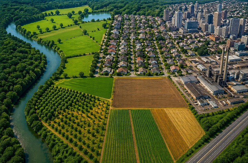
Practical Examples of Land Use Classification
Beginners often learn faster through examples.
Example classifications may include:
Rural Region
- Agricultural land
- Forest land
- Village settlements
- Water bodies
Urban Region
- Residential zones
- Commercial districts
- Industrial areas
- Transport corridors
These examples show how categories work.
Challenges in Land Use Classification
Although useful, classification may face challenges.
Mixed Land Uses
Some areas serve multiple functions.
For example:
- Residential and commercial mixed zones
- Agriculture with settlement overlap
These may be harder to classify.
Rapid Urban Growth
Fast development may quickly change land patterns.
This may require frequent updates.
Data Limitations
In some cases, limited data may affect classification accuracy.
Therefore, reliable data matters.
Why Accuracy in Classification Matters
Accurate classification may support:
- Better planning
- Sustainable resource use
- Reduced conflicts over land use
Because land decisions have consequences, accuracy matters.
Beginners and Career Relevance
Learning land use classification may help students interested in:
- Geography
- Environmental science
- Civil engineering
- Urban planning
- GIS and remote sensing
Therefore, it can be a valuable foundational topic.
Common Myths About Land Use Classification
Myth It Is Only About Agriculture
It covers many land categories beyond farming.
Myth It Is Only for Maps
It supports planning and management too.
Myth It Is Too Technical for Beginners
The core ideas can be simple to understand.
Clearing up these myths makes learning easier.
Why Land Use Classification Supports Sustainable Development
Sustainable development often depends on balanced land management.
Classification may support:
- Resource conservation
- Responsible development
- Environmental protection
Therefore, it plays an important role in sustainability.
Advanced Concepts in Land Use Classification
Land use classification is not just about labeling land—it also involves analysis, prediction, and planning.
Integrated Land Use Planning
Modern planning combines multiple land uses to maximize efficiency.
For example:
- Mixed-use developments (residential + commercial)
- Agroforestry systems (agriculture + forestry)
- Urban green spaces within cities
This integrated approach supports better land utilization.
Multi-Level Classification Systems
Advanced classification systems often work at multiple levels:
- National level (broad land categories)
- Regional level (detailed classifications)
- Local level (specific land parcels)
This hierarchical system allows both large-scale and detailed analysis.
Temporal Analysis of Land Use
Land use is studied over time to understand changes.
This may include:
- Past land use patterns
- Present conditions
- Future projections
Such analysis helps planners make informed decisions.
Land Use Planning and Policy
Land use classification plays a central role in planning and governance.
Role in Policy Making
Governments use classification data to create policies related to:
- Urban expansion
- Agricultural protection
- Industrial development
- Environmental conservation
Because policies shape land use, classification becomes a critical tool.
Zoning Regulations
Zoning laws are based on land use classification.
They help regulate:
- Building types
- Land density
- Industrial placement
- Environmental protection zones
Proper zoning prevents conflicts between different land uses.
Land Use and Sustainable Development
Sustainability is one of the most important applications of land use classification.
Balanced Resource Use
Classification helps ensure that land is used efficiently without overexploitation.
For example:
- Limiting deforestation
- Preventing over-urbanization
- Protecting fertile agricultural land
Environmental Protection
Land classification supports conservation by identifying sensitive areas such as:
- Forest ecosystems
- Wetlands
- Wildlife habitats
These areas can then be protected through proper planning.
Climate Change Mitigation
Land use plays a major role in climate change.
Proper classification helps:
- Reduce carbon emissions
- Increase green cover
- Manage natural resources
For example, preserving forests helps absorb carbon dioxide.
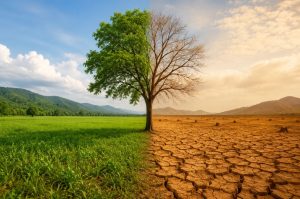
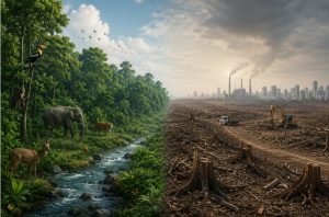
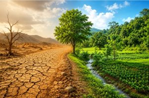
Land Degradation and Its Impact
Improper land use can lead to land degradation.
Causes of Land Degradation
- Deforestation
- Overgrazing
- Industrial pollution
- Unsustainable farming practices
Effects of Land Degradation
- Loss of soil fertility
- Reduced agricultural productivity
- Increased desertification
- Biodiversity loss
Therefore, proper land classification helps prevent misuse and degradation.
Urbanization and Land Use Challenges
Rapid urbanization is one of the biggest challenges today.
Urban Sprawl
Unplanned city expansion leads to:
- Loss of agricultural land
- Increased traffic congestion
- Environmental pollution
Infrastructure Pressure
Growing cities require:
- Housing
- Transport systems
- Utilities
Without proper classification, infrastructure planning becomes inefficient.
Informal Settlements
In many developing regions, unplanned settlements emerge due to lack of proper land allocation.
This creates challenges in:
- Sanitation
- Water supply
- Urban management
Role of Technology in Modern Land Use Classification
Technology is transforming how land is studied and managed.
Geographic Information System (GIS)
Geographic Information System is widely used for advanced land analysis.
It helps:
- Analyze spatial relationships
- Create detailed maps
- Monitor land use changes
- Support decision-making
Remote Sensing
Remote Sensing allows large-scale monitoring of land.
It helps detect:
- Deforestation
- Urban expansion
- Water body changes
Because of its accuracy, it is widely used in research and planning.
Artificial Intelligence and Machine Learning
Modern systems use AI to improve land classification.
These technologies help:
- Automate image classification
- Detect patterns in land use
- Predict future land changes
This makes classification faster and more precise.
Land Use Classification in Disaster Management
Land use data is critical in managing natural disasters.
Flood Risk Management
Classification helps identify flood-prone areas and restrict construction.
Landslide Risk Assessment
Hilly regions can be mapped to identify landslide risks.
Coastal Zone Management
Coastal land use planning helps reduce risks from:
- Storm surges
- Sea-level rise
Thus, classification supports disaster preparedness and risk reduction.
Real-World Applications of Land Use Classification
Land use classification is used in many sectors.
Agriculture
Farmers and planners use classification to:
- Select suitable crops
- Manage irrigation
- Improve soil use
Urban Development
Cities use classification to:
- Plan housing
- Design transport networks
- Allocate commercial zones
Environmental Conservation
Organizations use classification to:
- Protect forests
- Preserve biodiversity
- Manage natural resources
Infrastructure Development
Governments use it for planning:
- Highways
- Railways
- Industrial zones
Future Trends in Land Use Classification
Land use classification is evolving with technology and global needs.
Smart Cities
Modern cities use land classification for efficient planning.
Features include:
- Optimized land use
- Smart infrastructure
- Sustainable urban growth
Sustainable Land Management
Future systems focus on balancing development with conservation.
Big Data and Real-Time Monitoring
With advanced tools, land use can now be monitored in real time.
This improves:
- Decision-making
- Planning accuracy
- Environmental protection
Integration with Climate Models
Land use data is increasingly integrated with climate models to predict environmental changes.
Ethical and Social Considerations
Land use decisions affect communities and ecosystems.
Important considerations include:
- Fair land distribution
- Protection of indigenous lands
- Minimizing displacement
- Ensuring environmental justice
Therefore, land classification must be used responsibly.
Key Takeaways for Beginners
- Land use classification organizes land based on usage
- It supports planning, sustainability, and development
- Technology like GIS and remote sensing improves accuracy
- Land use changes over time and must be monitored
- Proper classification helps prevent environmental damage
Final Thoughts
Land use classification is more than just a technical concept—it is a powerful tool for shaping the future of our environment and society. From agriculture and urban development to conservation and disaster management, it influences how land is used and protected.
As the world faces challenges like population growth, climate change, and urban expansion, the importance of proper land classification continues to grow. By understanding these concepts, beginners can build a strong foundation in geography, planning, and environmental management.
Ultimately, effective land use classification supports a balance between development and sustainability, ensuring that land resources are used wisely for future generations.
FAQs:
Land use classification is the process of grouping land based on how it is used, such as for farming, housing, industry, or conservation.
It helps in planning, resource management, environmental protection, and sustainable development by organizing land into meaningful categories.
Land use refers to how humans use land (like farming or housing), while land cover refers to what physically exists on the surface (like forests or water bodies).
The main types include agricultural, residential, commercial, industrial, forest, recreational, transportation, and conservation land.
GIS (Geographic Information System) is a technology used to collect, store, analyze, and visualize spatial data for mapping land use patterns.
Remote sensing helps collect data from satellites or aerial images, making it easier to classify large areas accurately and quickly.